Team 44 - Muck 'n' Malarkey

 Where on Earth are we?


Follow us with SkyTag *

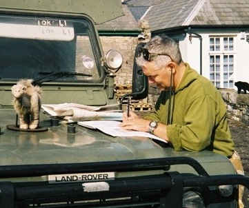
Due to the expense of roaming charges (and being born with only one pair of hands), Team 44's navigator is will be having to rely on good, old fashioned Map Reading, Route Assessment, Road Books** and Blind Luck to ensure that they complete the daily objectives and arrive, roughly on time, at Berchtesgaden  at the end of the Rally.

Mercifully (for you) you can follow our exploits without having the brave the tense and cramped confines of B'ambi's cab by logging onto the SkyTag website and following the route of us, and our fellow teams  (details below).


Follow us on SkyTag

* Now YOU can be Big Brother.

All the teams participating in the H4H 4x4 European Rally this year are carrying SkyTag trackers so, from just before the start of the event, at about 11:00 on Saturday 16th June, until the end of the Rally, 2000 miles and 6 countries later, you can log in and follow us.

Simply follow the link   http://www.skytag-gps.co.uk/events/h4h/teams/213-team-44-team  and follow us in real-time or check in daily for our route updates.

Stay tuned!

Navigation-wise we are also relying upon a secondhand Tomtom Go 300, numerous Beidecker maps of Europe and a healthy catering pack of Luck in conjunction with an inexhaustible number of the now infamous, mystical, hieroglyph-based tomes known as Road Books.**

**Road Books

Produced in a dark Druidic ritual by the light of black candles on All Hallows Eve by the wildly dancing and impishly prancing event organisers, Road Books represent, by means of Tulip Diagrams (an archaic hieroglyph form of pagan writing), every road junction decision, turn and obstacle for the entire Rally. 

Usually issued one at a time throughout the course of the Rally they are the hard-copy difference between a comfortable bed and a hot meal at the end of each day and icy, xenophobic isolation!

A tulip diagram is a pictorial representation of a navigation instruction in a rally roadbook depicting an intersection or a segment of road usually made up of a ball and arrow schematic. It may also include objects in sight of the road that can serve as navigational references. The ball at the base of the tulip denotes the point one will enter the intersection or road segment and the arrowhead shows the direction out of the intersection or away from the road segment. Tulip diagrams only approximate the configuration of roads and intersections as they appear upon approach, only including enough details to enable identification of the location.

Tulip diagrams are named after the Tulip Rally (Tulpen rally) in Holland where the format was first used in the 1950's.

The H4H 4x4 European Rally expects to use, on average, at least 2 road books per day covering over 2000 miles of on-road navigation.

The one good thing about them is that, at the start of the Rally, all but 45 of the (over 1000) Rally roadbooks are being carried by the organisers.  Of course the balance gradually shifts as the days pass until, on or around Day 8, the organisers' vehicle's chassis usually lifts clear of the road surface for the first time as the bulk of the paperwork has been distributed between the teams.

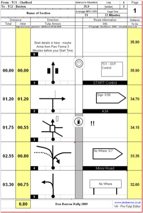
The knack of tulip diagrams is to have a driver who can simultaneously steer, observe, brake and reset the odometer working in symbiotic union with a navigator who can instantaneously overlay abstract imagery to their geographic surroundings whilst juggling up to 3 maps of varying scale, a persistent Tomtom voice and rising nausea.  After 15 or 16 days it becomes a little easier.

This free website was made using Yola.

No HTML skills required. Build your website in minutes.

Go to www.yola.com and sign up today!

Make a free website with Yola